
Mapping Center - Flood Zone, GIS and Zoning Maps
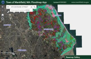
Marshfield GIS, Zoning and Flood Map
Using various layers available on Marshfield's online GIS mapping tool, you will be able to view the different Zoning Districts, Overlay Districts, Flood Zones, Barrier Beaches, parcels, structures, aquifers, easements, roadways, satellite imagery, elevation contours, and parcel ownership and assessment information. Tools are also available to calculate distances and area, take screen captures, print information and find latitude and longitude. The Building Department staff is available to help you navigate this site if you have any questions or difficulty.
The Marshfield GIS map can provide current and historical information on locations and elevations of FEMA Flood Zones. Clicking on a spot on the map will bring up a tab that will give you the Flood Zone that location is in, if any. Clicking on a structure on the map will bring up a tab that will tell you the Flood Zone information and the property ownership and assessment information. Links are also available in this tab to the Patriot Properties property assessment card.
FEMA Flood Map Service Center
If you would like more accurate current and historical FEMA Flood Insurance Rate Maps (FIRM), Flood Insurance Studies (FIS) or other flood hazard information, please visit the FEMA Flood Map Service Center. The FEMA Flood Map Service Center (MSC) is the official public source for flood hazard information produced in support of the National Flood Insurance Program (NFIP).
MassDEP Wetlands and Wetlands Change Areas Map
If you would like more accurate wetlands delineation maps and wetlands protection information, please visit the MassDEP Wetlands and Wetlands Change Areas Map. The Wetland and Wetland Change Areas Map displays MassDEP photo-interpreted wetlands, areas of detected wetland change, Notice of Intent locations and Natural Heritage Endangered Species Program (NHESP) certified vernal pools. Additional layers include assessors parcels, elevation contours, NHESP estimated habitat of rare wildlife, and FEMA Flood Zones.
MassMapper
If you would like more historical satellite imagery, regional information and statewide GIS information, please visit the MassMapper, an interactive map for Massachusetts. MassMapper was created by the Bureau of Geographic Information (MassGIS) as a modern replacement for the long-used Oliver online mapping application. It provides access to virtually all the MassGIS map layers and associated descriptive information, which can be displayed and queried.